CSE: ISP
LAST: -
VOL: -
Subscribe to our mailing list to receive news releases and other materials related to Inspiration Energy Corp. Your email will never be shared or sold and you can opt out at any time.
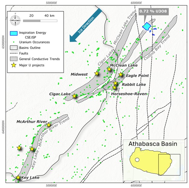
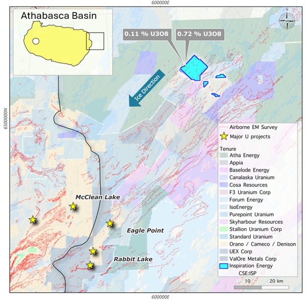
The Bentley Property is comprised of four mineral licenses encompassing a total land area of ~5,710ha (57km2) and is located 75 kilometers North-East of Cameco’s Rabbit Lake mine. The property sits on a potentially parallel structure to the Collins Bay Conductive trend that hosts the Rabbit Lake, Collins Bay and Eagle Point deposits. This environment has the potential for basement-hosted Uranium mineralization analogous to the Eagle Point model.
In 1969, ground EM and magnetic surveys were conducted over areas where airborne EM anomalies had been detected, along with an airborne spectrometer survey (AF 64L-0003). Additionally, diamond drilling, ground magnetic and EM surveys, and a U-Th ratio comparison were conducted over a portion of the area, but not covering the showing location (AF 64L15-0003). The following year, diamond drilling, ground geophysics, and geological mapping were carried out specifically over the showing area (AF 64L-0004), alongside ground evaluation across the entire area (AF 64L15-0004). Although positive results were uncovered during this mapping, the area was abandoned on in 1971.
In 1977, Taiga Consultants Ltd. obtained Permit No. 1 over the area. In 1978, Taiga submitted an exploration proposal and a regional geological description for the permit (AF 64L10-0016). The property was later renamed MPP 1041, and ownership transferred to Energy Reserves Canada Ltd. This entity conducted an airborne geophysical survey (AF 64L10-0017) and undertook regional and detailed lake sediment sampling, geological and glacial mapping, prospecting, and anomaly checks (AF 64L10-0018). The subsequent year, focus shifted towards a ground EM survey and follow-up prospecting of anomalous areas (AF 64L10-0019). Bentley has the potential to host vein, breccia and unconformity type Uranium systems similar to the producing mines south of the area.
Geological reconnaissance and mapping conducted in the broader area during the summer of 1980 by B.P. Scott (Scott, 1980), identified the area near outcrops categorized as granite and migmatite of the Aphebian Wollaston Domain. Isolated outcrops near the exploration site predominantly consist of granite with less than 50% inclusions of felsic gneiss or granodiorite gneiss. The earliest available records indicate that the area fell under Denison Mines Permit No. 2, which was staked on December 7, 1967. Exploration activities commenced the subsequent year, beginning with airborne electromagnetic (EM), magnetic, and radiometric surveys, along with geological reconnaissance (AF 64L-0002).
The most notable uranium showing on the property is located at the northern tip of the eastern shoreline of an unnamed small lake, ~15.3km to the east-southeast of Bentley Lake's eastern shore. Mineralization is found within a boulder of migmatitic biotite gneiss, corresponding to radiometric anomaly F-4, with scintillometer readings of 3900 counts per second (cps). Further analysis of the boulder revealed a U3O8 value of 0.11% (0.09% U) and 0.03% ThO2. Another boulder proximal to the first corresponds to radiometric anomaly F-3 and comprises quartzose biotite gneiss, yielding scintillometer readings of 1500 cps. Assay results returned 0.72% U3O8 (0.69% U) and 1.98% ThO2.